
Learn more about Routing & Navigation in the GoodMaps app.
Description
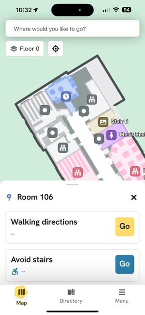
Indoor Routing and Navigation is the cornerstone of the GoodMaps experience. Select a destination, preview routes, and receive turn-by-turn routing instructions. Choose a standard walking route or one that avoids stairs, a feature designed for wheelchair users and others with mobility challenges. Turn-by-turn directions are available on the Map, in List view, or Augmented Reality (AR) View.
Highlights & Specifications
- In-app voice directions to a chosen destination.
- Turn-by-turn walking instructions for the fastest route.
- Avoid Stairs feature routes users to destinations without encountering stairs or elevators.
- Augmented Reality view overlays environmental information.
- Written list of routing directions is available.
- Notifications alert transit users of arrivals and departures, delays, track/terminal changes, emergencies, and maintenance issues.
GoodMaps 2.0 vs 1.0
- Both app versions offer similar routing experiences with destination selection and start routing.
- GoodMaps 2.0 includes:
- Visual Map & AR view
- Ability to avoid stairs
- List view of directions
FAQ
Can I explore a GoodMaps building without checking in?
Yes, you can remotely explore buildings by tapping “Explore All Buildings” on the Check-In screen. From there, select the building you wish to view. You will be able to access floor plans on a 2D Map and view additional information about each Point of Interest (POI) on the map. Additionally, you can explore the building Directory.
How accurate is the routing experience?
GoodMaps can guide you to your destination within a building with an accuracy of one meter. This represents a significant improvement over the accuracy provided by GPS (8-10 meters outdoors), Bluetooth trilateration (4-5 meters), and other methods.
How does the GoodMaps app know where I am?
GoodMaps utilizes cutting-edge LiDAR imaging and camera-based technology to capture comprehensive 360° data within a building. Once the scanning process is finished, our mapping team creates a digital rendition of the venue. This results in a highly precise two-dimensional floor plan, facilitating easy navigation for app users.