
Learn more about the 2D Map View in the GoodMaps app.
Description
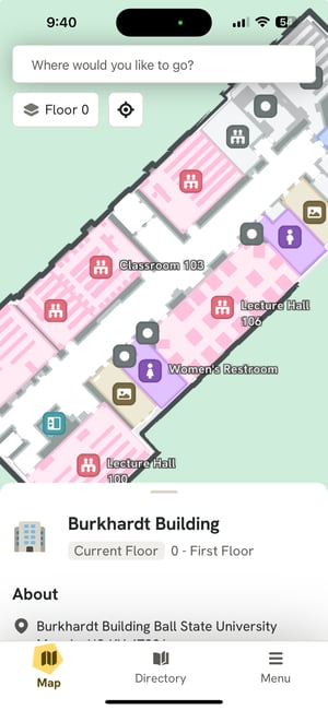
The 2D Map is a brand-new feature designed to offer sighted and low-vision users a visual aid for navigating buildings and routes. This map dynamically appears upon checking into a building and remains accessible at the bottom of the screen during navigation. Color-coded to signify different spaces, it serves as a reassuring guide, confirming you're on the correct path. Walking routes are depicted with yellow lines, while stair-free paths are indicated by blue lines, with the user's position marked by a blue dot.
Highlights & Specifications
- Explore building floor plans with ease using the Map.
- Color-coded areas denote various categories for clear identification.
- Pinch-to-zoom functionality and a recenter button ensure user-friendly navigation.
- Tap on a destination to preview routes from your current location.
- While en route, a zoomed-in version of the map at the bottom of the screen showcases your position and the route.
GoodMaps 2.0 vs 1.0
The 2D Map is an entirely new feature in GoodMaps 2.0, offering visual representation and route previews for sighted and low-vision users.FAQ
What do the colors on the Map signify?
Different areas are color-coded to represent various categories, including classrooms (pink), elevators and walkways (teal), exhibits (grey), food establishments (orange), lounges, lobbies, and common areas (blue), restrooms (purple), and stairs (brown).
Why isn't the Map showing my location?
If the blue dot marking your location is missing, GoodMaps may not have pinpointed your position yet. Here's what you can do:
- Hold your phone vertically, with the screen facing your chest and the back camera away from you.
- Slowly pan the camera left and right until your location is identified.
- You'll hear a success tone and see the blue dot appear on the map once your location is pinpointed.